OT: Severe Weather Discussion III

  • PLEASE check any bookmark on all devices. IF you see a link pointing to mandatory.com DELETE it Please use this URL https://forums.hfboards.com/

The Real JT

Meet the new boss. Same as the old boss. :(
Jul 2, 2018
8,150
7,762
Connecticut
What is it from? Always reminds me of Sandeman Port Wine… but I know it’s not.

Perhaps @Bones45 is an SCTV fan?

Maybe he’s even the one and only Guy Caballero?

67E0F307-F649-4DA4-AA0A-4235DC062B88.jpeg
 
  • Like
Reactions: MJF

Bones45

Registered User
Dec 7, 2005
18,769
8,315
N/A

crasherino

Registered User
May 9, 2013
7,342
2,836
I see about 12 new messages in this thread and I get my hopes up that there'll be some real updates about the impending snow apocalypse (or dribble).

Nope. Just you jive turkeys talking about sarcasm emojis. A disappointment development on many levels.
 

TeamKidd

Registered User
Aug 9, 2004
6,028
2,305
I see about 12 new messages in this thread and I get my hopes up that there'll be some real updates about the impending snow apocalypse (or dribble).

Nope. Just you jive turkeys talking about sarcasm emojis. A disappointment development on many levels.
we're stalling....
 
  • Like
Reactions: PK Cronin

TeamKidd

Registered User
Aug 9, 2004
6,028
2,305
oh BTW i know there were a few that asked about the Delmarva and I may have undersold the possibilities there, there is a brief window for some decent accumulating snows, especially in coastal areas
 

CupHolders

Really Fries My Bananas!
Aug 8, 2006
7,564
5,903
I see about 12 new messages in this thread and I get my hopes up that there'll be some real updates about the impending snow apocalypse (or dribble).

Nope. Just you jive turkeys talking about sarcasm emojis. A disappointment development on many levels.

I’m getting inspiration for my Snow Storm drink options. Liquor and bread… snow storm survival 101.

Oh yeah can’t forget… :sarcasm::cool::thumbu:
 

ML19

Registered User
Nov 21, 2011
1,304
678
Long Island
I see about 12 new messages in this thread and I get my hopes up that there'll be some real updates about the impending snow apocalypse (or dribble).

Nope. Just you jive turkeys talking about sarcasm emojis. A disappointment development on many levels.

Sarcasm emojis AND alcohol
 

Crashsunday

Registered User
Dec 18, 2006
589
246
San Diego
oh BTW i know there were a few that asked about the Delmarva and I may have undersold the possibilities there, there is a brief window for some decent accumulating snows, especially in coastal areas
Thanks for the update. We are trying to determine feasibility for an event this Sunday and any info for SE VA is helpful.
 

Bunk Moreland

Registered User
Mar 16, 2010
15,689
1,286
Long Island
Any updates from our meteorologist friends? We're so spoiled in this thread.

If you want snow it's looking good for the island with further east getting a lot snow. It sounds like even though we are 24 hours away stuff can still change cause the models have been shifting and going crazy the last couple days but it's trending towards a solid storm. National weather service is saying 8-13 for Nassau high winds up to 55mph+ Saturday evening.... I'm just some schmuck regurgitating what I read elsewhere so take it with a grain of salt. Smarts guys like kidd and peleches will give a better opinion.

My question for you guys is when should it start what kind of timeframe we looking at?
 

Chardo

Registered User
Apr 27, 2007
11,489
7,797
If you want snow it's looking good for the island with further east getting a lot snow. It sounds like even though we are 24 hours away stuff can still change cause the models have been shifting and going crazy the last couple days but it's trending towards a solid storm. National weather service is saying 8-13 for Nassau high winds up to 55mph+ Saturday evening.... I'm just some schmuck regurgitating what I read elsewhere so take it with a grain of salt. Smarts guys like kidd and peleches will give a better opinion.

My question for you guys is when should it start what kind of timeframe we looking at?
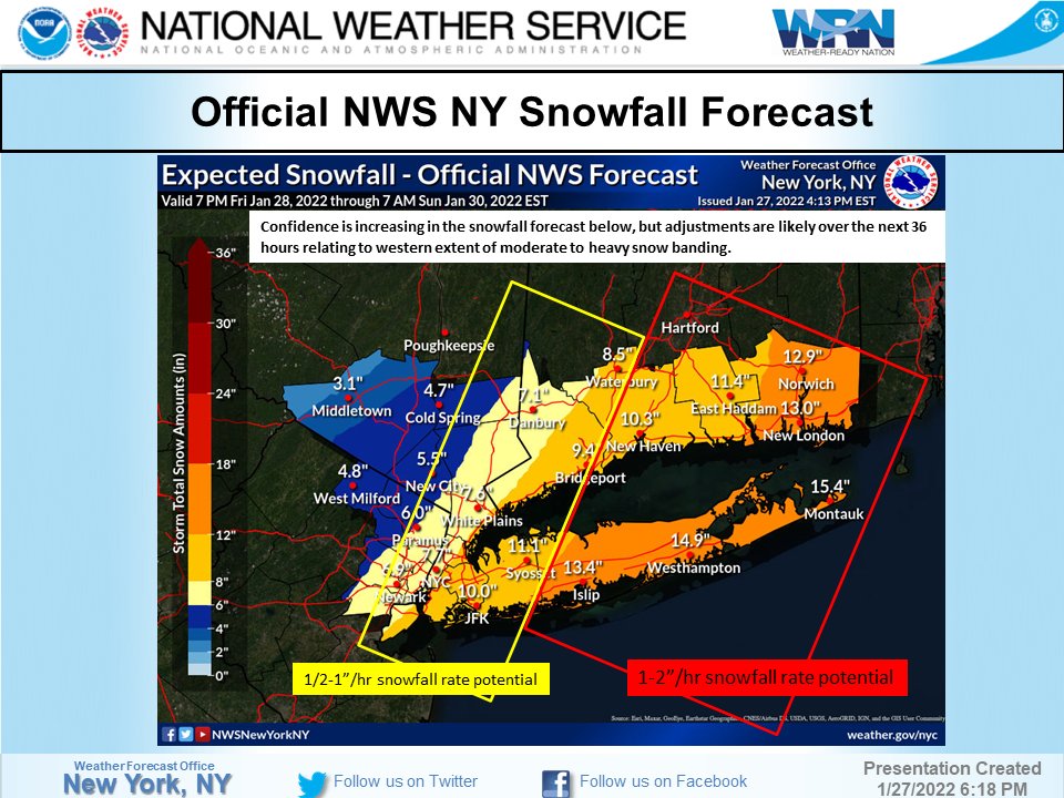
I love when my models shift and go crazy.
 

TeamKidd

Registered User
Aug 9, 2004
6,028
2,305
FKJSQnjVIAEXf8z


In the spirit of "We will all go down togetherrrrr" i'll just piggy back on the NWS forecast as I think it's probably pretty good. The models have been stubbornly divergent and unhelpful, but if any trend has been noted, it's one that has ticked up snowfall totals for the Island. Confidence in the forecast is very low, but if I had to, i'd put the foot mark right on the nassau/suffolk border and say 6-12 to the west, 12-18 to the east.

This is a very complex and dynamic storm, where many different parts have to come together to make this go, so it's very touch and go, but some light snow/snow showers develop friday with little or no accumulation, some steadier snow starts falling late night friday and progressively gets heavier overnight with the heaviest snow potential saturday morning into the early afternoon hours.

As I see it, this storm may evolve to have 3 pretty intense bands of snow - "The Full Monty" which is aimed squarely at SE Mass which will get a surefire Blizzard and 2+ feet of snow, "The Middle Child" band which is aimed at like Montauk and then "The Mystery Band" which could set up as a capper somewhere on central LI.

Another feature of this storm will be the very high Snow ratios as it will be quite cold - meaning a very light, fluffy, Cotton candy snowfall which could inflate totals. Also, don't sleep on the wind, as it will get quite windy on saturday as this storm Bombs out over the Atlantic.

I have no shame in saying that this is one of, if not, thee lowest confidence forecast i've ever given here. So prepare for Don Julio 1942, but keep some Bud Light on ice too.
 
Last edited:
  • Like
Reactions: Bones45

TeamKidd

Registered User
Aug 9, 2004
6,028
2,305
To get a bit wonky for a second, for those interested in the complexity - here is the newest NAM model -
floop-nam-2022012800.ref1km_ptype.us_ma.gif


...and the associated snow accumulation -

snku_acc.us_ma.png


and then this is the last run of the US model (GFS) -

snku_acc.us_ma.png


so, you pick'em - 7 or 33 LOL
 

TeamKidd

Registered User
Aug 9, 2004
6,028
2,305
snku_acc.us_ne.png
newest US model, GFS now joins the party and crushes us too... this may actually happen....would not be surprised to see a Blizzard watch posted at this rate
 
Last edited:

MJF

Hope is not a strategy
Sep 6, 2003
27,357
20,190
NYC
To get a bit wonky for a second, for those interested in the complexity - here is the newest NAM model -
View attachment 502634

...and the associated snow accumulation -

snku_acc.us_ma.png


and then this is the last run of the US model (GFS) -

snku_acc.us_ma.png


so, you pick'em - 7 or 33 LOL
I’m going 8-9 for Elmont and eastern Queens, 14-15 for central Suffolk.
 

Ad

Upcoming events

Ad

Ad