The Crypto Guy
Registered User
- Jun 26, 2017
- 29,180
- 38,832
That means some area, likely much northwest, could potentially see that much in an isolated area.The second image in this thread says 30" next to StormMax.
That means some area, likely much northwest, could potentially see that much in an isolated area.The second image in this thread says 30" next to StormMax.
and then it can quickly refreeze into ice. Big yikes.is the warmer temperatures that turn snow into slush so quickly.
That means some area, likely much northwest, could potentially see that much in an isolated area.
yeah thats in very small pockets that somehow find themselves in constant heavy snowbands throughout the storm.Gotcha.
I thank you for it. It was truly a awesome timeI’m trying to bring back the tradition
") . Those threads really got me into tracking storms then. I forget which user it was but they were awesome and predicted so much with their models. It was actually a huge help.
. Those threads really got me into tracking storms then. I forget which user it was but they were awesome and predicted so much with their models. It was actually a huge help.Most are still 12-18inches. Unless you are going by News12 which historically have always been the worst when it comes to forecasting snow.Mods didn’t like the snow threads because folks got excited early and started throwing around big numbers that weren’t accurate and the mods didn’t want to have to verify/vet it so they shut it down.
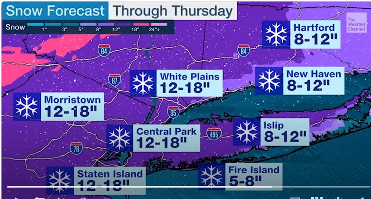
The models overall have been pulling back totals a bit for the city east and immediately North and West as well, 6-12 is a solid bet right now (was 12-18). Once you get farther north and west the totals likely go up.
Can’t wait to take the snowboard down the streets!

I use the actual weather models, not the News graphics. To a T all the models so far have all backed down on the NYC metro totals, including the latest round of models run this morning. Some are still being released so we'll see what they show. 6-10 for the city and Island is fair, but it's looking more and more like some sleet is likely to mix in that 6-10 shaded area with a dry slot after, leading to lower totals in and around the city and LI.Most are still 12-18inches. Unless you are going by News12 which historically have always been the worst when it comes to forecasting snow.
But even they arent too far off with everyone else.
Not trying to be a wise guy, but aren't these meteorologists using the weather models too?I use the actual weather models, not the News graphics. To a T all the models so far have all backed down on the NYC metro totals, including the latest round of models run this morning. Some are still being released so we'll see what they show. 6-10 for the city and Island is fair, but it's looking more and more like some sleet is likely to mix in that 6-10 shaded area with a dry slot after, leading to lower totals in and around the city and LI.
I'm hoping to get buried, but trying to be realistic here.
lol they are using the same models, but it takes a few hours for the media to adjust to the model runs and make their new graphics for TV. They also like to wait for a couple of rounds before big adjustments (the right move) to make sure the model adjustments are legit. What was a jackpot for coastal areas and the city now looks to be a classic North and West jackpot, but still a significant storm for the metro, just not historic levels.Not trying to be a wise guy, but aren't these meteorologists using the weather models too?
But yes I know they are wrong quite often
Urban Heat Island Effect.I feel like snow accumulation in NYC is always less impressive than forecasted. Maybe because there's so much heat from below ground?
Ah gotcha.....haha well it's been awhile since we had any type of accumulating snow.....I think I can ease my way back into it without a half a foot+ without having historic levels so quicklylol they are using the same models, but it takes a few hours for the media to adjust to the model runs and make their new graphics for TV. They also like to wait for a couple of rounds before big adjustments (the right move) to make sure the model adjustments are legit. What was a jackpot for coastal areas and the city now looks to be a classic North and West jackpot, but still a significant storm for the metro, just not historic levels.
I go to Americanwx user are fairly accurate.I like to go read weather forums when a big snowstorm is forecasted. I enjoy how they nerd out and argue the Euro vs the NAM. The models are all over the place. Banding. Dry Slots. The low is too close to the shore...
Apparently this storm can produce 2 feet of snow under the right conditions or if the precip line creeps north NYC might only get a few inches.
People are saying to check the dew point tomorrow to see where the low pressure sets up.
I lived in the UWS back then, and the piles of snow were just unbelievable — waist high in some parts. But the serenity and calm the day after, before all the slush formed due to traffic, were sublime.The early February blizzard in ‘13 was epic. Winter storm NEMO I believe. Most snow in 24 hours in CT on record. Anywhere from 24”-36”. We got something like 32” where we are in Fairfield County. It was over my boys and my dogs heads! We got 14” either a couple days before or after also, can’t remember. Legendary
I like to go read weather forums when a big snowstorm is forecasted. I enjoy how they nerd out and argue the Euro vs the NAM. The models are all over the place. Banding. Dry Slots. The low is too close to the shore...
Apparently this storm can produce 2 feet of snow under the right conditions or if the precip line creeps north NYC might only get a few inches.
People are saying to check the dew point tomorrow to see where the low pressure sets up.
I think the low pressure is going to set up at the dot by the half boards for a one timer.It's exactly how the way you set up the power play determines what you produce on it.