
Crazy weather thread
- Thread starter beowulf
- Start date
-
Work is still on-going to rebuild the site styling and features. Please report any issues you may experience so we can look into it. Click Here for Updates
You are using an out of date browser. It may not display this or other websites correctly.
You should upgrade or use an alternative browser.
You should upgrade or use an alternative browser.
LadyStanley
Registered User
JMCx4
HUTCH Lives!
Explanation by the U.S. National Hurricane Center to take some of the Crazy out ...
NHC Cone Heads in a New Direction
Posted on August 12, 2024
Robbie Berg, Warning Coordination Meteorologist; Daniel Brown, Branch Chief, Hurricane Specialist Unit; Larry Kelly, Hurricane Specialist
You may have seen our announcement back in February that we at the National Hurricane Center would start producing an experimental version of the cone of uncertainty in mid August that depicts coastal and inland tropical storm and hurricane watches and warnings for the continental United States. Well that time has come, and even though we don’t currently have a tropical cyclone threatening the continental United States, we want to refresh everyone on some of the things you’ll notice about the new cone, and some of the things that you should be aware of when using it, particularly since this will be the biggest change made to the NHC cone graphic since 2017.
But first a comment about the new cone being “experimental.” In National Weather Service (NWS) vocabulary, “experimental” means that a potential new product or service is being tested by the NWS, and partners and users are encouraged to provide feedback during a comment period. This also means that the product may, at times, be a little rough around the edges, may not be available on a consistent basis, and probably should not be used yet for critical support decisions. After the comment period is over, we go through your feedback to determine (1) should the product go operational, (2) if it does go operational, are there things in the product we need to modify, or (3) do we need to create an updated version of the product and open up another comment period. Think of it like a pharmaceutical company testing a new drug: it sometimes takes multiple rounds of testing before the drug is approved by the U.S. Food and Drug Administration for human consumption. If you want the nitty-gritty on the public comment period, refer to the NWS Public Information Statement or description page on the NHC website. Comments can be provided in the NWS Survey on the NHC Experimental Tropical Cyclone Forecast Cone Graphic. One important note to keep in mind: the current operational version of the cone will still be available and will not change during the experimental period. ...
Read & See more at: NHC Cone Heads in a New Direction | NOAANHC
LadyStanley
Registered User
JMCx4
HUTCH Lives!
LadyStanley
Registered User
Category 6 - 99% Invisible
On the campus of Florida International University, in Miami, there’s a place ominously named “The Extreme Events Institute.” They map the risk of storm surge for the whole Caribbean, and study how the public perceives the threats from natural disasters. They’re also home to the International...
 99percentinvisible.org
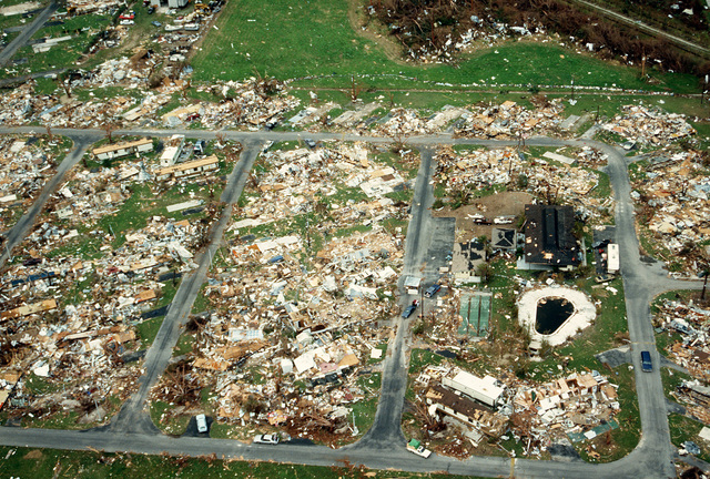
99% Invisible podcast talks about hurricanes, categorizing the damage. And how it might need to be modified 50 years after being created.
LadyStanley
Registered User
LadyStanley
Registered User
JMCx4
HUTCH Lives!
Jovavic
boohoo, Pens "fans", BOOHOO
LadyStanley
Registered User
As long as there is sufficient water, it is not an issue.
300+ days of sunlight is great for solar energy collection to reduce dependence on fossil fuel generated power.
LV and Southern Nevada (where the majority of folks live in the state) recycle the water used domestically (inside house/building) and return to Lake Mead (to reuse again). Only irrigation water is "lost" (plus evaporated water).
However we are in an extended drought and it's not looking good for a wet winter (snow melt off is main source of water).
BigBadBruins7708
Registered User
As long as there is sufficient water, it is not an issue.
300+ days of sunlight is great for solar energy collection to reduce dependence on fossil fuel generated power.
LV and Southern Nevada (where the majority of folks live in the state) recycle the water used domestically (inside house/building) and return to Lake Mead (to reuse again). Only irrigation water is "lost" (plus evaporated water).
However we are in an extended drought and it's not looking good for a wet winter (snow melt off is main source of water).
and to add to the crazy we're gonna snap from summer to fall. 105 today, low 90s this weekend and next week calling for highs between 83-85 and lows around 60
JMCx4
HUTCH Lives!
It's almost like you live in a desert ...and to add to the crazy we're gonna snap from summer to fall. 105 today, low 90s this weekend and next week calling for highs between 83-85 and lows around 60

BigBadBruins7708
Registered User
It's almost like you live in a desert ...
No one's complaining bud. And it's almost like we set every possible heat record this year, hence why it's newsworthy.
LadyStanley
Registered User
No one's complaining bud. And it's almost like we set every possible heat record this year, hence why it's newsworthy.
LadyStanley
Registered User
JMCx4
HUTCH Lives!
One woman's approach to combating Crazy weather ... the phenomena, not the thread ...
LiveScience.com (Adriana Zuniga-Teran): Ancient civilizations knew how to keep cool in deadly heat. We need to resurrect that lost knowledge now.
LiveScience.com (Adriana Zuniga-Teran): Ancient civilizations knew how to keep cool in deadly heat. We need to resurrect that lost knowledge now.
LadyStanley
Registered User
JMCx4
HUTCH Lives!

LadyStanley
Registered User
JMCx4
HUTCH Lives!
LadyStanley
Registered User
LadyStanley
Registered User


- Feb 18, 2018
- 4,815
- 7,055
LadyStanley
Registered User
Nah. Waste of $$, time. Would rather watch hockeyNeed to hit the casino…